Report by Roman Tol
On February 28th 2008, the Netherlands Architecture Institute (NAi) organized The Mobile City conference, in collaboration with the research programs ‘Mew Media, Public Sphere and Urban Culture’ (University of Groningen) and ‘Playful Identities’ (Erasmus University Rotterdam). The conference concerned the interplay of physical and digital spaces, and the influence of locative and mobile media on urban culture and identities.
 As I entered the spacious hall of the NAi, the first thing that caught my eye was a table filled with Lego. The colorful interlocking plastic bricks and accompanying array of gear, figurines and other parts stand for imaginatively exploring scenarios and possibilities in a serious form of play. Contemporary cities are the realization of a vision that was once upon a time played with, perhaps even on a table filled with Lego. Similarly, Locative Media could be seen as a modern form of serious play, fostering creative thinking, as users build metaphors of their identities and experiences using new media technologies within a presented scenario. On the one hand, Locative Media offers new tools for designers to envision future planning; on the other hand designers will have to think differently about cities as the technology implicates mobility, practices of everyday life, politics and aesthetics.
Architecture, as Ole Bouwman (director NAi) emphasizes in the opening speech of the conference, is a pillar of society in which a shared heritage is stored. The building of the NAi, for instance, is shaped around numerous proposals, political decisions, and cultural trends. In this sense one could say buildings are representations of the zeitgeist, and the city is an archive that preserves an intellectual, civilizing, cultural and political tradition. Cities present scenarios that tell a story about its makers and users. Moreover, they show us where we are, and possibly where we are heading as a society. Architects help us locate and provide a shelter, a form of enclosure and a home. It is the duty of architects to secure and carefully maintain this task. Currently digital technologies continue and aid this mission; network technologies allow archives to be accessible all over the world, and security technologies protect citizens from potential threat. However, as Marshall McLuhan aptly states in Understanding Media (1964) “We become what we behold. We shape our tools and then our tools shape us.” Current trends in placing CCTV cameras, tracking and tracing technologies throughout urban space, may soon reach a point from which we cannot return, after which technology imprisons publics and affects who and what we are. Instead of brick facades our future cities may be thought of as glass cages where everyone is watching one another.
For some, paranoid theories are merely entertaining narratives. Nonetheless, there is no denying that digital technologies implicate notions of urban space and place. So what can really be said about the merging of physical and digital ‘reality’? The term ‘Locative Media,’ initially coined in 2003 by Karlis Kalnins, seems to be appropriate for digital media applying to real places, communication media bound to a location and thus triggering real social interactions. Locative Media works on locations and yet many of its applications are still location-independent in a technical sense. As is the case with digital media, where the medium itself is not digital but the content is digital, in Locative Media the medium itself might not be location-oriented, whereas the content is. Thus wireless and mobile media have re-introduced questions of space and place. Cyberspace and the so-called ‘real world’ converge into what Lev Manovich called ‘augmented reality’, and in this ‘augmented reality’ it does not matter where you are. On the other hand, the technology lends itself to surveillance and control, thus in the end it might be important where you are. The network in most instances might be invisible but can you remain out of sight?
OPENING THINGS UP VERSUS CLOSING THINGS DOWN
Malcolm McCullough (Associate Professor University of Michigan) opened his lecture concerning ‘urban inscriptions’ by saying Holland feels equally homely as Michigan. As a citizen of the mobile city, Malcolm belongs to multiple places and communities. Our daily life is increasingly managed in mediated ways. However, layers of information have long been part of urban density. Locative Media let us combine these mediations with organizations in space. That in turn combines many senses of the word ‘architecture.’ However, Malcolm added, Locative Media are not as new as the hype might make you believe “layers of information have long been part of urban density, and their applications are not just in way finding.” Malcolm’s talk touched upon four main themes in relation to urban markup: history, derive, advertising and ambiance.
Inscriptions give cities more than an aesthetic character; it also sets cities apart from one another. In fact, if every city were the same all would be boring. It takes great cities to make traveling from point A to B an exiting experience instead of a tedious trap. “Whether as grand expressions carved in stone facades, mundane signage in the streets, or the various props used by communities of practice, an information layer has shaped urban experience.” Now that layer intensifies. Much as electrification did for power infrastructure a century before it, pervasive computing brings mobility, precision, personalization, and embedding to urban annotation. On a street level, participants build up an invisible information infrastructure, something that could be referred to as urban computing. At the same time the building environment is shaped as a media platform, the rise of corporate media related skyscrapers function as landmarks in the city. The KPN building for instance is a familiar sight in Rotterdam that functions as an orientation point as well as an attraction.
Dérive is a notion used by Guy Debord in an attempt to convince readers to revisit the way they looked at urban spaces. The concept means to aimlessly walk, or drift, through the city streets being guided by the momentum and space itself. The basic premise in Debord’s theory of Dérive is that people are trapped in the practices of everyday life, by looking at the city by following their emotions they can break with their daily route, routine and enclosed space. Cities in fact are designed in ways to direct and control its publics. Cities are complex structures in which movement and mobility is managed by its plan, for instance road signs tell one where to go at what speed and where to not go between what times, when to stop and when to continue. But also the architecture controls the flow of people by means of the way in which certain areas, streets, or buildings resonate with states of mind, inclinations, and desires. Debord argues that people should explore their environment without preconceptions, in order to create a better understanding of one’s nature; as one becomes aware of its location, one can value and comprehend his or her existence. The idea is that people built forth from their insights and seek out reasons for movement other than those for which an environment was designed. Bringing an inverted angle to the world can make people assign new meanings to familiar places, produce new forms of social interaction and make public space a place where one stops to look.
Locative Media technology and artistic practices may assist publics to gaze in new ways and offer possibilities for social interaction. However, Malcolm noted, the city is increasingly getting polluted with advertising. Contemporary cities are taking the shape of a spectacle as public spaces are bombarded and overloaded with images, messages, art, signs, texts and ads. Moreover, everywhere media facades erect and our streets, the public stage of political movements, theater, playing children and social contact, are increasingly becoming virtualized with electronic screens and projections, taking away the public function of open space. Over the last decades our public space has gradually more been privatized; streets, squares and parks are more and more covered with brands and logo’s; public domains such as schools, universities, and libraries are ever more dependent on corporate sponsoring and turning in a shopping mall variant; public transport such as busses and trains are equally being privatized and transforming into mobile billboards. GPS enabled technologies might continue this trend.
GPS enabled wireless devices, such as ones cell phone, currently allow for personalized data to be sent to its user in the form of Location Based Services. When a personal profile – set up by the user via a survey, or based on the user history – is coupled to a pool of other profiles supplied by other users, then statistical algorithms can suggest other likes and dislikes, based on the similarity of ones profile to other user profiles in the pool. Consequently the user may be sent information when he or she is in near proximity of the product or service that is in accordance with the user’s taste. Yet, the question remains: “how much information is pollution?” In fact, in the past, Malcolm adds, broadcasting ads via radio was controversial (1920’s). Nowadays there are speakers blasting commercials in public spaces. Where is this leading? How much more?
In Sao Paulo there is a ban on outdoor advertising, including billboards, neon signs, and electronic panels. On January 1st 2007 this city of 11 million, overwhelmed by what the authorities call visual pollution, pressed the “delete all” button to offer its residents unimpeded views of their surroundings. Transforming the landscape goes hand in hand with a change in culture. Contemporary culture seems based on marketing and ads. Yet, I cannot stop thinking how dull, grey and maybe even unsafe Time Square would be without its flickering neon lights (or projections of yourself). On the other hand, it is different being a tourist on Time Square as it is being a resident. So shouldn’t place based media make public space more ambient? In ancient times way points and milestone were introduced to the city to make travel more convenient. Orthographic mapping came in the 15th century; fly posting and city street signs in the 19th; and in the early 20th century travel guidebooks, electrification and street lightning made the city more secure, itinerant and mobile. Currently tracking and tracing technologies offer new challenges in urban mark-up, they may make everyday life more pleasant, yet it can enhance annoyance as it increases information junk. When placed on a time line, public advertising is a relatively new occurrence. The privatization of public space and the bombardment of one-way corporate messages have a disturbing effect on ambiance, and add even greater urgency to the belief that concentration of media ownership has successfully devalued the right to free speech by severing it from the right to be heard.
ARTISTS SPEAK OUT
Why do artists choose tracking and tracing technologies in their works? How did they get started? Are there socio political statements announced through Locative Arts? Can Locative Arts be used to push technological progress?
While studying graphic art and mixed media in Utrecht, Esther Polak used a compass to help her navigate through the city. Her bad sense of direction had always been a frustrating factor in her everyday practices. When GPS and navigation technology developed to a consumer friendly affordable level, Esther started mapping her routes. The first time when see saw a route being visualized was after a sailing trip she took with friends on the Lauwersmeer. Not only did the map show the route of the boat it also illustrated the shape of the lake. Analysis of their sailing technique explained the wind direction. Moreover, the map pointed out decisions they made during the trip, decisions that tell a story, for instance when and where they sailed to shore in order to have lunch.
 The notion of maps telling a story makes me think of The Russian campaign of 1812-1813 by Charles Joseph Minard. It shows the troops of the Napoleonic army on a two-dimensional map as they advanced to Moscow and retreated towards Poland again. The thickness of the line is proportional to the survivors at that moment. The lower graphic shows the temperatures.
Esther decided to take exploring the visual and documentary possibilities of GPS one step further with her AmsterdamREALTIME project (2002 in cooperation with Waag Society, Jeroen Kee). Ten inhabitants of Amsterdam carried a GPS tracer with them for one week. Their routes through town were made visible on a projection screen in the exhibition space. The traces on screen form an alternative, highly personal map of the city. The maps provide visualizations of everyday

routes individual participants take, and in a way the routine they are stuck in, but above all they tell a story about the user. When one of the participants was given his personal map, which only had a few short lines – the man only walked around one corner – his reaction was ecstatic, he told Esther he was going to keep the map for his grandchildren.
This and the encouraging international interest inspired Esther to develop the collaborative MILKproject. In this project a European dairy transportation was followed from the udder of the (Latvian) cow, to the mouth of the (Dutch) consumer. All people who played a role in this chain received, for a day, a GPS-device that registered their movements. Again the results put forward fascinating stories. A Christian farmer, for example, drove the milk to a supplier via an ‘unintended’ detour. When he was confronted with the diversion his father asked at the top of his voice: “What are you doing there?” If it was a woman he was meeting there remains unsolved, nonetheless the map again presented a storyline. Currently the project has found its way to Nigeria. NomadicMILK records and visualizes the routes of both nomadic herdsman and regular dairy transport. NomadicMILK differs from MILKproject in that it makes use of a newly developed visualization tool: a small robot draws the tracks directly on the ground in lines of sand, allowing the tracks to be shown to the Nigerian participants along the road. Again the outcome offered remarkable anecdotes. One of the participants pointed out at what point in the track his wife had left him for another, making others wonder why he still walks that route.
The way that we experience urban place and the built environment is defined to a large degree by the places we go for social encounters, meeting: the places we go to work, for consume, to learn and for entertainment. James Stewart (Institute for the Study of Science, Technology and Innovation in the University of Edinburgh) observed an occurring alteration in these places: meetings are now less constrained to offices, shops and fixed points of service, and can take place in a range of environments, in particular the rise of branded places: coffee houses, transportation hubs, customized meeting places, and informal, locally branded spaces that attempt to offer a quality of environment for all sorts of meetings. There is a domination of branding, and consequently corporations shape publics. Brands say something about ones identity, location and milieu. Meeting with friends at “Starbucks” is different then meeting them at “Wendy’s”. In this context Starbucks stands for a mature social environment and the latter represents an adolescent (and perhaps even anti-social, as fast-food restaurants are designed – with sterile white lightning and uncomfortable chairs – to have people spend as little time as possible behind their tables). Therefore, James argues, it matters where people are when they meet, that branding is an important aspect of place, and that technologies have a major role to play in mediating brand and meaningful human interaction. In order to test this hypothesis James and his team are currently running an experiment that entails volunteers logging into the locations they visit by taking a picture of the place. Their Facebook friends are informed of where they are by text and WAP. You can try by adding the ‘BrandedApp’ on Facebook. This experiment investigates Virtual Presence, the images that people choose to represent where they go, and the linking of the ‘status’ concept in online Social networking, with ‘logging in’ to physical places.
Thomas Engel (The Saints, a Amsterdam-based company developing content for mobile devices) took the opportunity to plug a 3,5 minute NavBall commercial – that includes product placement for Heineken. Thomas argues NavBall, a team-based soccer game played simultaneously on 6 to 22 mobile telephones, is the logical result of trends in mobile content, outdoor gaming, and the upcoming European soccer championship (summer 2008). Whereas many of the discussed project presentations were about rediscovering the city, education, or establishing social encounters, NavBall seems primarily centered on fun. Players are focused on their screens more then the physical surrounding, moreover, the physical surroundings act as an obstacle that players have to work around. Of course exiting sociable encounters and discovery of the city may occur, however this seems secondary to engagement in the game.

Games Atelier on the other hand, aims to use the urban environment as inspiration, context, and a trigger for participants to co-design, actively play and share their results. In Games Atelier, Ronald Lenz (head of the Locative Media research program at Waag Society) explains, students from secondary schools are invited to create and play their own location-aware mobile games. Central in the game is the theme ‘citizenship’. Games Atelier evolved from four earlier projects developed by Waag Society (an Amsterdam-based medialab which researches how creative technologies can lead to social innovation in education, culture, healthcare and the public domain). It all started with the previously discussed AmsterdamREALTIME, which opened up new possibilities for playing with tracking and tracing technologies. Four years later in 2005 the Locative Media department of Waag Society developed a mobile learning game named Frequency 1550, in which “students are transported to the medieval Amsterdam of 1550 via a medium that’s familiar to this age group: the mobile phone”. Frequency 1550 took place again in June 2007. The game uses 3G cell phones and network to allow students to compete in finding answers to questions about the old city of Amsterdam, for history class excursion and assignment. Frequency 1550 explores the social potential of location-aware devices, inspired by the use of tracking technology and wireless media, human relationships, movement and identity, the project seeks to extend and re-appropriate the functions of locative technologies by exploring ways in which they can be socially constructive and facilitate new dynamics to occur within everyday school life. Children are taught to look beyond city facades, interact socially and technically, and move through the city in new ways.
The possibilities of Locative Media and studies in serious gaming have triggered interest from the academic community. In 2006 the University of Amsterdam and the Hogeschool van Amsterdam collaborated with Waag Society to develop a mobile package that allows students to use the urban environment as a source of knowledge, information, and study. The Mobile Learning Game Kit (MLGK) consists of a piece of mobile equipment allowing data to be collected. It displays topographical models of urban networks in such fields as culture, politics, and economics. The MLGK enables users to independently observe, analyze, and present data. The MLGK and its content are developed by users themselves and transferred to new users.
The concept of sharing and playing advanced in Waag Society’s recent project named 7Scenes – a community platform for multi-user real-time gaming with mobile and location-based technology. Waag Society considers 7Scenes one of the first Web 3.0 application platforms. With Web 3.0 they point to a future where the Internet is truly connected to our physical world. So how does 7Scenes differ from (Google Maps) mash-ups? “Of course there are some similarities – we all create layers on top of the world. Both 7Scenes tries to go beyond that focusing more on creating scenario and rule-based location interaction and broadcasting: visualizing scenes (live).”
These projects are not only about concentrating context in a coordinate point, nor are the projects merely about gaining greater understanding of place through the cell phone screen. Frequency 1550, The Mobile Learning Kit, 7Scenes and Games Atelier are not museum or digital touring guides; the focus is on opening up spaces of play through which context may be discovered. Moreover, local and otherwise hidden places possibly will get noticed.

Laurence Claeys & Marc Gordon (senior researchers at Bell Labs-Lucent, Antwerp) moved the broad research of the use of the touch-paradigm to interact with things forward into different test cases concerning the relation between home and city context. Their projects aim to empower users to stage, participate in, engage with, and experience media on the ‘cross-reality web’. One of the SmartTouch projects involved a ‘Do it yourself city experience kit’. Another was an album in which city souvenirs may be collected, conserved, collaged and shared with. In their research Laurence and Marc observed a long tale of creative initiatives in the city (the city mass is most dominant and the sociable city is in between). There are a lot of creative proposals but attention is given to commercial initiatives. So, the problem is who will fund people playing around the city?
Currently Locative Media projects receive large academic and commercial funding. Various theorists assert the history of media to have moved from analogue to digital to virtual and now to locative. Commercial ventures are interested in Locative Media projects for their experimentation value. The city is used as a testing ground for technological applications, usability and reliability. Christian Nold (a London-based artist and lecturer) observed that Locative Media do not exist anymore as a community but has splintered into a number of different directions; on the one hand Locative Media can refer to the technology (mobile devices connected to the Internet, security equipment and navigation technology), on the other hand it refers to outdoor gaming and art practices with the use of portable location aware devices. What has emerged, Christian states, is a strong focus on audience and the specificity of place. Christian believes Locative Media should focus on gathering, sharing, playing, visualizing, imagining, contextualizing, archiving and meeting educative challenges. Locative Media has a decentralizing value that allows social spaces to be opened up and empower communities.
Locative Media also allows publics to experience familiar places from an alternative perspective. In Sensory Deprivation Mapping participants were deprived of sight and hearing and asked to roam the city in order to create a map based on other senses. The result is a map based on how fresh the air is or how windy certain areas are.
Locative Media has a quality to bring the local, hidden, repressed and silent to the surface. People are constantly bombarded with signs (ads, road-signs, neon lights, screens, facades) when traveling through urban space, making it difficult for certain places to stand out, places that might tell an interesting or important story. In one of Christian’s projects people in Stockport (UK) were asked to draw emotional arousal in relation to their geographical location in the town. The Emotion Map of Stockport had one striking detail: the Mersey River – which flows through the town center – was not represented. The participants had drawn the shops next to it, some were not even aware there was a river. Emotion Maps can point out suggestions for improvement. In the case of the Mersey River Christian suggests that there is a whole range of cultural and physical interventions that could allow people to re-engage with the river, such as canoeing trips under the Merseyway, marking the course of the river in the street or drilling spy-holes through the road surface to allow people to see and hear the Mersey.
Maps can be used to form communities to adjust the community. We should move away from the fantasy of the mass; the public is you and your friends. Christian has observed a change in publics; communities are becoming more important and the local is being recognized. The alteration of the notion of the public will change the method of advertising too. Advertising as we know it is designed to reach the mass, this will disappear when the transition to community emphasis continues: people do not want to advertise to their friends because for most advertising is considered an anti-social act.
CITY/PRISON: DISCUSSING PARANOIA AND REFUGE
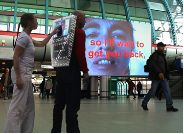
Before a panel of experts took the conference stage Anne Nigten (Lab Manager V2_Institute for the unstable media, Rotterdam) presented StalkShow, a project done in collaboration with media artists Karen Lancel and Hermen Maat. StalkShow deals with the threat of insecurity and isolation in public space. It invites the audience to give this threat a personal face and space; to show both its horror and its beauty. A performer carries an interactive wearable billboard containing a laptop with a touch screen around these spaces. People are invited to touch the touch screen and to navigate through texts about the threat of insecurity and isolation. Connected to the backpack is a webcam that shows the ‘intruders’ face on the screen (and in 2006 at ArtInPro, Moscow, on an urban screen). The act of touching and being in contact with a stranger’s personal space is for most people, Anne says, a creepy experience. There is an invisible barrier to overcome, and most ‘victims’ felt as if they were performing a forbidden act. What the project tries to display is that, like the technology used, the zone of intimacy is shifting to a more pervasive intrusive one. The question becomes: who is stalking whom? The act of making contact with someone from the back, instead of face to face, enhances the whole idea of being watched. The touch brings it to a close. After a series of lectures and presentations that mainly concerned the playful and innovative character of Locative Media it was interesting to see a project that highlighted the augmentation of surveillance culture.
The panel discussion that followed touched upon various themes, but was dominated by the fear of advancing and promoting privacy intrusive technologies. The panel contained four experts from different domains, allowing the topics to be discussed from diverse perspectives. Rob van Kranenburg (head of Public Domain, Waag Society) is involved in negotiability strategies of new technologies, predominantly ubicomp and RFID (radio frequency identification), the relationship between formal and informal in cultural and economic policy, and requirements for a sustainable cultural economy. Marc Schuilenburg (who teaches at department of Criminology, VU University Amsterdam), co-author of “Mediapolis: Popular Culture and the City” (2007), is mainly focused on the risk society. Joris van Hoytema (BBVH Architects & Multimedia) worked on “Baas op Zuid”, an architecture game in which players can design their neighborhood, and make decisions that directly influence their environment. Nicolas Nova (researcher at Media and Design Lab, Swiss institute of Technology, EPFL) is researching gaming experiences (location-based applications, ubiquitous computing) in mobile/urban contexts.
Rob observed an increase in agency, yet with it there is a lack of unpredictability and poetry. Performance artists (happenings, Yoko Ono, situationists) play with the certainties and expectancies people find in everyday life. These certainties are increasingly being formed by technology. Artists should be encouraged to again wake people up from the routine of everyday life. Our life, Rob adds, is increasingly dependent on technology. Of course technology is able to take away tedious activities, yet the more we (the West) outsource our activities to technology the duller we become. “In Delhi they can still fix their car! Just imagine if here in the West the hardware breaks down…”, Rob shouts. Our fixation on technology and outsourcing of activities is dangerous, it may lead to a militaristic society; Napoleon was able to conquer Europe on a horse, just imagine what he could have accomplished with a mobile phone.
On the other hand, Joris interrupts, technology is able to assist participatory decision-making to take place from local level. In relation to his own projects Joris believes the technology is used for good. The technology motivates people from the same neighborhood to get in contact with each other. Furthermore, it provides them with a chance to partake in urban planning (for instance by means of referenda, allowing residents to speak out their need for more green, parking space, youth facilities, etc.). Nicolas understands the positive aspects of location-based media, but underlines the difficulty in motivating people to use it. It is difficult to mobilize people, currently there is not enough awareness, and moreover, people do not know how to communicate with each other. “I don’t know the email address of my own neighbor” Joris says. “So why doesn’t every place get its own email address?” Marc agrees with the capability of Locative Media to assist notions of collective intelligence (following Levy) and smart mobs (following Rheingold). What this brings, Marc adds, is a break off from autonomous creations; design and production is a collaborative process, every creation is build forth from previous ones, and moreover, spaces are increasingly being capsulated, supporting community building, which add to shared production. “There is no more genius” Marc states, “the ‘senius’ is the new genius”.
Marc believes our attention should focus on citizenship, which, as the word in French articulates, is bound to physical space. Our spaces are increasingly being capsulated (museums, plaza’s) and guarded by mobile media. Currently urban places are more and more being privatized, and this adds to the increase in security techniques. Office buildings, commercial zones, and adverting space are kept safe by mobile media (iris scans, mosquito’s, code). In fact what this brings are enclosed spaces. Hence, technology not only unites, it also divides! Therefore, concentration should be more political; continuation of privatization and commercialization bring forth a city under corporate control.
Nicolas agrees with notions of a gated community, yet believes the focus should be on designers; they facilitate serendipity, assist the discovery of new people, and create awareness of local identities. Rob counters by saying the role of designers at present is only limited to the work that has already been done. Their input and decisions are restricted to what color something should be or what visual shape something needs to have. Therefore designers should be included in the early stages of the process. Rob proposes a level down participation. “Currently the public is only given security cameras, mosquitos and other controlling technologies, if we don’t stop this now we can never get back!” Rob adds loudly. “Designers should see how they can give trust”, Marc replies, “right now the lowest risk factor is ‘low risk’, there is no ‘no risk’. Again the focus should be more political”. “There is no way back”, Rob states, “you can walk around the city covered in aluminum, but you can only keep that up for a few days”.
IN CONCLUSION
Architecture encloses, occupies, it is for the people, stands for values, and is hatched in stone. Architecture covers privacy, security, property, gives individuality, and representation. There are optimistic and pessimistic ways of looking at technological advancement. Ambient, ubiquitous or locative media, like all new technological systems, tend to become hidden and disappear at precisely the moment that they become important. They weave themselves in the practices of everyday life. Infrastructure is embedded, transparent, temporal or spatial reach or scope, is learned by its users, and is linked to conventional practices (e.g. electricity). From the cerebral discussions, the project presentations, and questions from the audience it can be concluded that there are three domains which technological expansion and the ‘hybridization of space’ influence: consumerism, militarism/security, and urban activism (art + activism). Technology is placed in the city with good intentions, but now the architecture is there for control. Database coupling and searches result in that we have become statistical persons. Political choices establish how algorithms are determining networks; it can be used commercially, militaristic, or for reformation.
The topics moved beyond city architecture and touched upon urban culture and identity. Moreover, it questioned the interplay of physical and digital urban spheres in an age of mobile media. The conference organizers Martijn de Waal and Michel de Lange put together an outstanding event. The conference was formatted in a clear and well thought through way; after a broad theoretical overview of both architecture and Locative Media (Ole Bouwman and Malcolm McCullough) a series of practical projects set the scene in contemporary urban culture, after which a panel discussion analyzed current transitions from differing professional perspectives. The conference was wrapped up by Stephan Graham (who is discussed in more detail in my Masters of Media blogpost). In the end, I left the NAi a little worried and a whole lot wiser.