Pokémon Go, Facebook check-ins, Google Maps, public transport apps and especially smartphone apps are increasingly becoming traceable and locatable. As ‘check-in’, features in social media and games grow in popularity they pinpoint users in relation to everything else in the network, making physical context an essential input for online interactions. But what are the practical consequences of the increased proliferation of devices that can determine our location? Could one say that surveillance is already taken for granted as we passively provide our coordinates to others?
The idea that one’s data is being collected for numerous surveillance-related motives is no longer part of a distant dystopia. Within this logic of data collection, tech giants (first and foremost Google, followed by Facebook, Apple, and Amazon) increasingly assign value not only to our identities but also to how we interact with physical space. Location-based services are being recognized as participative ways to normalize surveillance: a process through which leakages of personal information are seen as ‘normal’ or ‘natural’ in everyday life. Although privacy and maps are two words that rarely share the same sentence, we start to understand more and more that spatial annotations can be revealing when linked to possessions, habits, and other types of behaviors.
While online maps may for some time have been considered as neutral pieces of technology, geographers, sociologists, and historians are now treating them as cultural-based artifacts with an ideological bias that inherently accompany their design. In other words, maps are being reinterpreted as structures of power: they distribute authority between different individuals or groups of people. According to J. Brian Harley, cartographer and historian, ‘political power is most effectively reproduced, communicated, and experienced throughout maps’. In general, this power can be related to the production of cartographic documents and the systems that enable it, to map literacy, to conditions of authorship, and to the very nature of the political statements that are made by these new pieces of technology.
Maps can indeed be understood as a kind of language used to mediate a particular view of our world. When seen this way, they can be associated with certain ‘cartographic discourses’ or with persuasive and rhetorical applications, and not just as something meant to name and to locate. These discursive mechanisms of maps – and their modern representatives, the geographic information systems – show how they became a political force in our society. More important still is what they tell us at a second glance, what is actually being mapped behind their most external layer. Here I want to overcome the primary superficiality in which digital cartography is being addressed, making way for insights into the assumed-natural state of mapping technologies and their narratives of use. I choose Google Earth as the primary example to make clear what is at stake when we unknowingly navigate its digital surface.
GIS and Google Earth: an Overview
Caitlin Dempsey, editor of GIS Lounge website, writes that geographic information systems (GIS) are modern extensions of the traditional cartographic document, with one fundamental similarity and one essential difference. The similarity lies in the fact that both contain a base map to which information can be added, yet the difference is that there is no limit to the amount of data that can be linked to a GIS, which effectively transforms static objects into dynamic, malleable ones. Indeed, analogue maps are extremely simplified in order to accommodate a volume of data that can be easily read and understood by a broad audience. On the other hand, GIS are often replete with layers that can be visualized or hidden according to one’s desire without compromising the overall legibility of the document.
Professor of Geography at Oklahoma State University Thomas A. Wikle notes that when computer-aided mapping techniques came into existence in the early 1950s, ‘traditional pen-and-ink cartographers’ were not very enthusiastic: these new features were considered rigid and could not match print media in terms of flexibility. Some limitations of early graphical technologies varied from pixelated edges to the use of typographic sets to represent complex data such as population densities. However, from the mid 1970s to the early 1980s, these mapping systems saw a rise of popularity among specialists, policymakers, and the military. Their acceptance grew due to the increased data they could hold, allowing cartographers, in Wikle’s words, ‘to experiment with ephemeral arrangements’.
Enlarge
With the democratization of internet in the 1990s, geographic information systems went through a huge development and consequent exploitation of their commercial possibilities. The adoption of web browsers as a feasible way to mediate GIS improved their usability,
making the possibility to compare a broad variety of online data a distinct quality in modern cartography. Hence, from dedicated pieces of hardware and software in the 1990s, GIS have turned into a compelling internet application that allows people to browse GPS coordinates, satellite imagery and third party services, without considering, at least until recent times, its possible political, economic, and cultural outcomes.
In the midst of a modest rush to settle market standards, Google Earth ended up being one of the most popular and widely used web-based GIS, alongside Yahoo Maps and Bing Maps. Originally called Earth Viewer and owned by Keyhole Inc., the system was a part of the many acquisitions Google made. According to its own website, Google Maps was live in February 2005, and just two months later, satellite photographs were added to better represent its visualization potentialities. In April of the same year, mobile phones adopted the Google Maps application in the US, offering driving directions and geolocated information to users. Finally, in June, Google Earth became operational, allowing people to take virtual journeys to any place in the world. Google Earth has since been downloaded more than one billion times.
Essentially, Google Earth provides the chance to view our planet as a virtual globe, a three dimensional representation, with the possibility to examine more zoomed and detailed information. By navigating it, it is possible to explore a mix of aerial images and 3D models that comprise not only landmasses but pathways, buildings, architectural complexes and entire cities; not to mention other locations like oceans, the moon, Mars, and outer space. In addition, since Google enabled people to directly upload geographic information through its own social network, the Google Earth Community, the system gained substantial practical applications. For example, in education, it permits students to access how cultures have evolved and interacted in different locations. This community is also used to track diseases and illustrate the social context of health problems.
However, according to Michael Harrington and Michael Cross, writers and IT experts, other uses of Google Earth are less conventional. As an example, police throughout the world have used it in a variety of ways, from investigating crimes to sharing information with others, incorporating the system into the field of ‘digital forensics’. Traditionally, forensics use scientific techniques to investigate and establish facts in a criminal case through the analysis of fingerprints, fibers, and photographs. In digital forensics, pieces of evidence are gathered from computers and other devices capable of storing information. This includes geolocated data generated by mobile phones, tablets, GPS units, and a range of other software, but also satellite and aerial imagery extracted from web services.
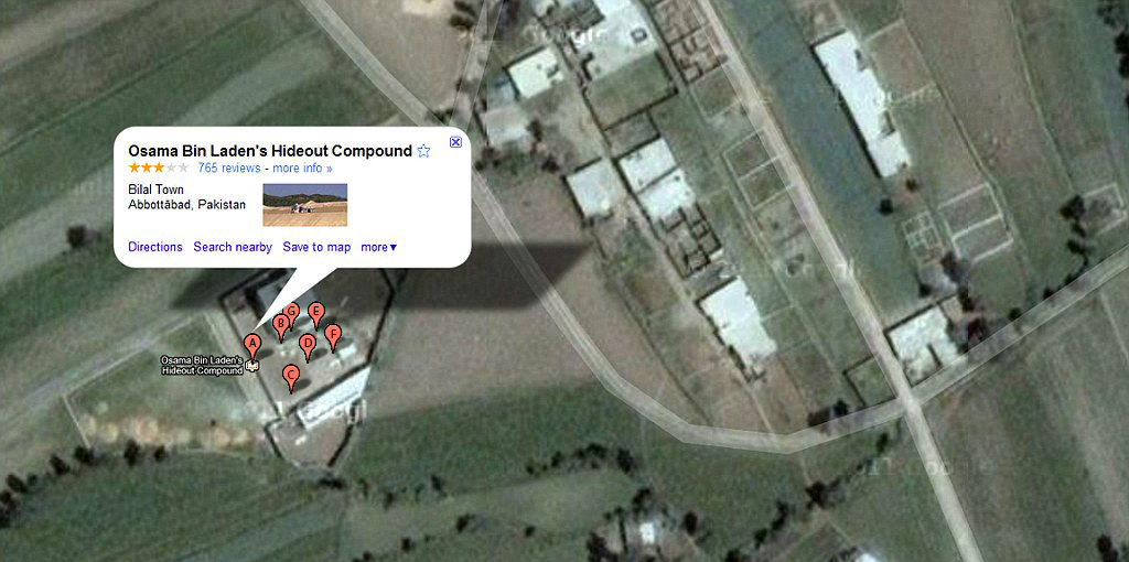
A remarkable case involving such techniques happened in 2011. On May 1, social media platforms like Twitter buzzed with rumors of Osama bin Laden’s death. Even before the US president Barack Obama took the podium to give the announcement, people headed to Google Earth to ‘pin’ the location of the strike based on geographical information previously leaked on the internet. By using the Historical Imagery plugin, a timeline function that displays how terrain has changed over time, users started to compare aerial photos between 2001 and 2005, finding significant construction vestiges on the spot. This was later described by the American security agency as a bunker with 12- to 18-foot walls and two heavy security gates. This particular event sparked the possibility of a prior agreement between Google and the US government to supply the second with more detailed information about the surroundings of bin Laden’s hideout.
Enlarge
Although GIS technologies enable the possibility to fight crime and terrorism more accurately, they also raise questions concerning a significant reduction in autonomy of nation-states in a number of ways. Harrington and Cross mention that, while a criminal investigation would customarily be conducted by members of law enforcements, digital forensics opens the field to private organizations that own these technologies and technicians such as members of IT departments. In this scenario, GIS experts and not lawmen may be the first to identify a breach in security or analyze crucial evidence hidden in aerial records, transferring the power to generate proofs, or even incriminate individuals, to the private sector of society. This same phenomenon can also be seen in other areas. From community management to traffic control, digital maps and the possibilities that they create are undermining the sovereignty of the state over its resources, opening it up to the free market.
Commentators are seeing the empowerment of users by mapping platforms with excitement. But the new advancements that merged geolocated technologies with social interactivity turned out to be also a valuable source of information for numerous interested parties. The network that emanates from this symbiosis permits, if not forces, users to leave traces for others to access. For Martin Innes, one of the world’s leading authorities on policing and social control, any remote possibility to track this residual data, from checkpoint mechanisms available for public review (as in Foursquare and Facebook) to more subtle forms of leakage that can be accessed by intermediators (such as coordinate entries in Google Maps), are tied to surveillance methods. When combined with other variants like financial income or educational status, this data can form the basis for detailed predictive profiles. Although internet companies often claim that they deal with homogeneous sets of information, protecting individual identities, it is virtually impossible for us to know whether particular records are being intercepted by third parties.
The Digital Representation of the Earth: A Critique of Google’s System
Enlarge
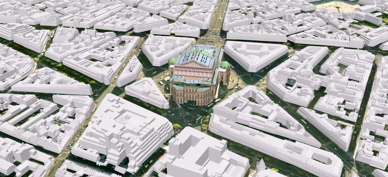
There is one main difference between Google Maps and Google Earth that tell us something about how these systems were conceived: while the first works with fixed top-down 2D perspectives, mostly useful for everyday logistics, the second embodies a 3D rendering function intended to accurately represent our world in its entirety. For Clement Valla, a Brooklyn-based artist, Google’s capacity to merge multi-resolution pictures from different sources (private companies, government agencies, mapping institutes) combined with its high-end solution on developing 3D models is what makes this company so successful in creating a god-like (or drone-like), uninterrupted navigation of our planet. In practical terms, the novelty of Google Earth lies in its power to integrate an enormous quantity of data in a seamless, realistic representation that seems trustworthy to users.
Issues of credibility in relation to maps have been widely addressed by academics in the field of cultural geography. Mark Monmonier, writer on the societal impacts of mapping technologies, states that a good map tells a multitude of little ‘lies’, eliminating or distorting details to help users see a chosen aspect of reality. Indeed, displaying all information available about a particular area would be very confusing, graphically speaking. Ultimately, the value of a map is based on its capacity to generalize form and content for the sake of practicality, but also to accomplish political and ideological goals. As an example, the distortion of the land masses in the Mercator Projection served not to facilitate navigation but to reiterate colonial supremacy by displaying the centrality and global importance of Europe.
But how to claim inaccuracy or misleading representation in relation to an automated, mathematical model of our globe that presents photography and scanned surfaces as factual statements? Are the mechanical processes used to create such portrayals neglected by cultural criticism due to their non-human nature? Although users might rightfully be expected to connect photographic maps to ‘reality’ because of the strong association between aerial imagery and absolute space, philosophers like Henri Lefebvre note that this point of view comes from a misunderstanding: the idea that space can be seen as a mere container rather than something culturally shaped. He writes: ‘Space is not a pre-existing void, endowed with formal properties alone. To criticize and reject absolute space is simply to refuse a particular representation of it.’ Therefore, following Lefebvre’s thoughts, geographical information systems like Google Earth, which supposedly are an evolution of traditional maps, should be interpreted as producers of unstable signifiers that are heavily subjected to cultural influences, and not as objective spatial visualization platforms.
But since the mechanical aspects of modern cartography have surpassed the craft of mapmaking, the practical consequences of any cultural background encrusted on these new artifacts slowly began to be masked. According to John B. Harley, this has to do with the non-human quality of the actors involved in these mapping systems. He observes that the division of labor caused by the move from the handcrafted age to the age of printing made maps more reproducible and further disrupted the notion of a single creator behind them. Interests and motivations embedded in these artifacts became less obvious or harder to trace as the overall sense of authorship has been replaced by a more artificial, mass-assembled one. In general terms, the application of technology supposedly freed cartography of its inherent subjectiveness. This seeming objectivity however is a serious danger to our understanding of the actual purposes of these mapping practices.
This phenomenon was accelerated by the integration of aerial imagery in the production of maps. Because of their straightforward resemblance to facts, photographs have been historically classified as indexes, as opposed to symbols. Susan Sontag argues that photographed images do not seem to be statements about the world but pieces of it: ‘miniatures of reality that anyone can make or acquire’. She continues with saying that, due to their physical qualities (light waves that actually arrive at the camera when reflected by objects), ‘pictures passes for incontrovertible proof that a given thing happened or existed’, a record of a material reality. Thus, from its use by the Paris police in the nineteenth century to its development into an effective tool for surveillance and control, photography has been a way to reaffirm our capacity to coherently represent phenomena that exist in the real world.
Enlarge
In addition, while regular photographs are usually linked to an author that witnessed a certain moment in time, satellite imagery is generally associated with the apparatus that ‘generates’ it. This further distances modern GIS from a sense of subjectivity, emphasizing its disembodied, unbiased nature that performs a series of mechanized techniques. Moreover, it could be said that this distance became even greater after the release of Google Earth’s previously mentioned timeline function.
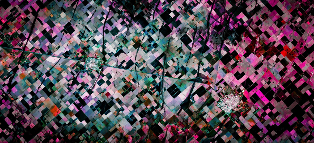
However, these images are heavily manipulated in order to produce a seamless representation as the one that Google delivers to its users. Since it is impossible to employ them directly from the hard drive of satellites or drones, these aerial photographs are preprocessed, selected, data mined, georeferenced, edited, and merged – a range of steps operated by codes, algorithms, filters, human and non-human labor. Also, an immense but unnoted IT structure is needed to extract the spectral information of this imagery. Satellite sensors perceive a far wider range of the electromagnetic spectrum than the human eye, which can only see a small fraction of it. So, technically speaking, these images are not even photos in a normal sense; they are a combination of digital bits that have been subjected to intense modification to form figures.
Enlarge
As a result, the cartographic process renders the indexical nature of aerial imagery obsolete. It transforms each photo in a numerical pattern of yes/no choices registered within a computer’s memory that does not have any reference in reality. Once transformed, pushed, or twisted by the post production, the decisive moment that connects any photograph to an exact time and space is then stretched to systematic additions of content. According to Clement Valla, the interval between the mechanical record of the terrain and the time at which Google Earth’s globe appears on our screens is indeed used to edit a very specific and tendentious model that selectively chooses its inputs of data. Thus, for one, there are just clear skies in Google’s version of the Earth (with clouds strategically placed in a couple of sensitive locations) but also plenty of contrast, saturation, and light; in fact, it’s always daylight.
Another issue has to do with the underlying criteria that determines the display of high-resolution images or just pixelated, blurry ones, not allowing users to equally access their sites of interest. Grinderud, Rasmussen, and Nilsen, writers on GIS, explain that the most accurate commercial output of satellites have a pixel size of approximately 50 cm2, while military usage can employ images from the same source with a resolution of less than 10 cm2. This shows a difference in the vernacular and the political usage of this technology, since some actors have far more agency compared to others when it comes to accessing such tools. Moreover, by imposing these algorithmic standards on us, Google Earth determines what is worth looking at and what we have the right to observe – building a grammar or a set of rules for seeing.
The most ambitious achievement of Google’s efforts is the notion that we can hold the entire world in our hands. This puts the audience in a comfortable position where knowledge can be acquired by browsing freely through space. But to enter coordinates in its search box also means to allow Google Earth to store valuable information about desired places, routes, schedules, means of transportation, and so on. By simply entering the platform, we disclose our IP address, type of browser, the speed of internet and processor capacity. Zooming can give hints on places of interest while searching for directions identify street addresses of users. Viewing traffic shows our probable routes to and from workplaces and using Street View can expose who our friends, family, and coworkers are. Emailing or sharing a link, as a final example, will locate other people for Google and their possible meeting in an event.
Google Earth, and the whole mapping technology that supports it, in this way threatens the ability of every internet user to remain opaque to third parties inspections, raising a serious question concerning security and freedom in the network. By offering an effective tool to browse geolocated data, this platform ends up establishing a practice of surveillance that brings unilateral benefits to Google if we compare it to the limited, fabricated agency provided to ordinary Google Earth explorers. According to Clement Valla, users can only solve their own accessibility problems, which overshadows a much larger truth: that Google Earth is essentially a corporate database disguised as a photographic representation. In this database our homes, our cars, our habits, and perhaps even ourselves all exist in terabytes of data.
Such an analysis frames the illegibility of these systems to a non-technical audience and addresses the internalization of surveillance in our culture, where social practices are created and shaped by location-based technologies. As mobile devices grow into an important support for our daily life, not in the least through giving us directions everywhere, GIS and cartographic applications are becoming the underlying structure that maintain this complex network active. So Gordon and Souza e Silva are right when they mention that location awareness is both a cause and a consequence of the use of networked systems and it is possible that maps will soon develop into the main organizational logic of the web. As people become more and more comfortable with letting their mobile devices track their coordinates, personal information is ceasing to be private to become part of the digital surface of the Earth – ubiquitous and geolocated at the same time.
But the appearance of a network of mobile devices organized by geographic properties may not just influence the catalogation of information but also the tangible world that contains it. In other words, portable media, mapping technologies, and networked surveillance can add whole new connotations for the way we understand and experience cyberspace, challenging the virtual/physical dichotomy that characterizes our times. In a near future, it is more likely that we will not only virtually inhabit Google’s corporate database, but Google’s database may also become substantial and all-encompassing in the most concrete sense of these terms. If nowadays the power of mapping technologies are rather pervasive, yet limited to the network, in this prospective condition this power finally becomes transcendent of Google’s hardware and software, impacting users in now unimagined ways.
Gustavo Velho Diogo is an independent designer and photographer from Brazil. He recently graduated in Arts and Culture Studies at Radboud University with a MA thesis on surveillance and the politics of digital mapping technologies. In the beginning of his professional life, Gustavo worked as a map artist in a publishing house in São Paulo, what introduced mapmaking techniques and the post processing of satellite imagery to him.
References
Farman, Jason. 'Mapping the Digital Empire: Google Earth and the Process of Postmodern Cartography'. Sage: London, 2010.
Winer, Federico. Ultradistancia.
Gordon, Eric & Souza e Silva, Adriana. Net Locality: Why Location Matters in a Networked World. Blackwell: Oxford, 2011.
Grinderud, Knut; Rasmussen, Haakon & Nilsen, Steinar. GIS: 'The Geographic Language of Our Age'. Tapir Academic Press: Trondheim, 2009.
Harley, J.B. Maps, Knowledge and Power. Cambridge University Press: Cambridge, 1988.
Harrington, Michael & Cross, Michael. 'Google Earth Forensics: Using Google Earth Geo-Location in Digital Forensic Investigations'. Elsevier Inc.: Amsterdam, 2015.
Martin, Innes. Understanding Social Control. Open University Press: London, 2003.
Monmonier, Mark. Spying With Maps: Surveillance Technologies and the Future of Privacy. The University of Chicago Press: Chicago, 2002.
Sontag, Susan. On Photography. New York Picador: New York, 1977.
Valla, Clement. 'The Universal Texture'. Rhizome.
Wikle, Thomas A. 'Geographic Information Systems: Digital Technology with a Future?' Computer & Society, Vol. 21 - ACM SIGCAS: New York, 1991.